
Every year, regions of the world are hit by natural disasters such as hurricanes or floods. As a result of climate change, these phenomena have not only increased in number and severity, but it has also become more difficult to predict when they might occur. Although the areas most prone to these hazards try to take proactive measures, many sources of information are not timely enough or are of limited use.
Luckily, satellite technology is a powerful tool that can overcome the shortcomings of more traditional methods. A live satellite images online viewer can provide immediate information about what is happening, helping everyone involved to make better decisions or act quickly in the aftermath.
The Power of Satellites in Disaster Response
The current state of remote sensing, with dozens of satellites orbiting our planet, means that we can obtain information with unprecedented quality and frequency. Current satellite imagery stands out not only for its high resolution, but also for the number of spectral bands captured by the instruments on board the satellites. This is further enhanced by the greater analytical capacity we currently have at hand.
Thus, communities that make use of this cutting-edge technology can perform various tasks, such as monitoring the development of an ongoing natural disaster, areas already affected and potential trajectory, planning evacuation routes based on their accessibility, coordinating rescue operations once the disaster has passed, even if terrestrial telecommunications fail, or assessing damage by comparing images before and after the event.
How to Easily Access A Live Satellite View Of Earth
Searching for, viewing, and downloading satellite images is very simple and can be done on multiple websites and software programs. However, analyzing them can be cumbersome if you must export and import data between different programs. Fortunately, there are comprehensive online platforms that allow anyone to complete the entire process in just a few clicks, without needing to be an expert.
Each platform has different features, although some are common to all of them: an image search engine with a built-in filter to help find the most relevant images, some vegetation indices, the ability to create areas of interest to automate the acquisition of new images, and the export of data in different formats.
Other platforms, such as EOSDA LandViewer, go a step further and integrate advanced features for more comprehensive analysis. In addition to the most common vegetation indices, LandViewer integrates other lesser-known indices and even allows you to create custom indices. Change detection, time series analysis, data clustering, and multi-layer maps help to extract as much information as possible from the images. The free plan allows to download 15 images per month with no cost, enabling new users to try out the platform without obligation before moving on to the next level.
Natural Disaster Types and How Current Satellite Images Help
The versatility of satellite imagery enables a wide range of observations, regardless of location or the information sought. In terms of natural disasters, the most current satellite imagery is commonly used in the following cases:
- Floods. A live satellite view can help identify flooded or submerged areas, thereby understanding which access routes are available to rescue services. By combining satellite imagery with topographical data, experts can create maps to determine the areas most at risk of flooding, so that public authorities can build defences.
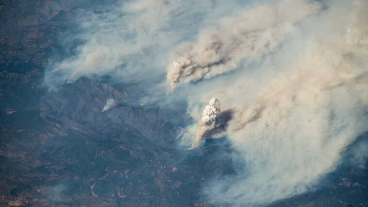
- Forest fires. Satellites can detect heat signals and small fires before they can even be seen from the ground. They also allow smoke columns to be seen remotely. Thermal and infrared images make it possible to assess the direction and speed at which the fire is spreading, enabling firefighters to take effective action to extinguish it.
- Storms and hurricanes. Weather satellites can monitor the formation and movement of hurricanes in the ocean, providing early warnings for coastal communities. In the case of storms, satellites enable the tracking of clouds and the understanding of wind speed.
- Earthquakes. Although difficult to predict, satellites play a vital role in detecting and assessing ground deformation prior to an earthquake.
Empowering Communities Through Open Data
One of the most disruptive aspects of satellite technology is the large amount of free data available. This allows any user, whether an expert or a citizen eager to explore on its own, to make use of this data without the need for prior training or a significant financial outlay. By democratizing access to satellite data, communities can stay informed about what is happening around them, participate in mapping and environmental monitoring projects, and even verify the news they read or hear.
In an era in which climate change has altered the frequency and severity of natural disasters, having accurate and reliable information is a luxury that cannot be dispensed with. Real-time satellite imagery has helped transform the response to natural disasters, increasing the resilience of the most vulnerable communities to these phenomena and protecting the lives of the people who live there with reliable early warnings.
About the Author
This sponsored article from EOS Data Analytics was written by Kateryna Sergieieva, a Ph.D. in information technologies and 15 years of experience in remote sensing. She is a scientist responsible for developing technologies for satellite monitoring and surface feature change detection. Kateryna is an author of over 60 scientific publications.
GIPHY App Key not set. Please check settings